Introduction
In November 2012 I had my terrestrial TV aerial relocated to another corner of my chimney stack so that it doesn’t overhang my solar panels. Birds were perching on it and making a mess on them. Consequently I needed to check my TV aerial direction to be sure it points to the transmitter.
The aerial engineer worked until it was dusk when he re-attached my aerial to the chimney stack. That left him little time to adjust my TV aerial direction. I could see from the ground that the initial direction didn’t align with the aerials of my neighbours. I checked the TV picture and on some channels I got interference on my digital Freeview signal causing blocking (corrupt squares of varying sizes) on the picture. So I asked him to rotate it until it matched the other aerials nearby. The picture has been good since.
In this article I show how terrestrial TV aerial direction is accurately set using a compass instead of measuring the signal strength.
I accept that measuring signal strength at the aerial is the best method especially when an aerial is pointing towards an obstruction such as a building or electricity pylon.
Terrestrial TV Aerial Inclination
Terrestrial TV is transmitted on the UHF frequency band between 300MHz and 3,000MHz. This band offers a line of site transmission path. Because of the curvature of the earth it’s difficult to see beyond ten miles at ground level. That distance is increased by mounting transmitting aerials on very tall masts and receiving aerials on chimney stacks. The aerials can then see each other over the horizon.
This all means that TV aerials need to point at the horizon with their Centre Bar horizontal. They can be inclined to capture the signal when it comes over the top of a tall building.
I’ve seen many TV aerials pointing to the ground nearby. They get moved by strong winds when they have insecure mountings. I suspect their owners have poor reception and don’t realise what the cause is.
How I Calculated My Terrestrial Freeview TV Aerial Direction
- I determined the Latitude and Longitude of my TV aerial using Google Earth. I pointed to my house and read the Latitude and Longitude on the status bar at the bottom of the screen, e.g. 52°53’7″N, 1°25’30″W (not my actual co-ordinates due to privacy concerns).
- Then I found the TV transmitter on Google Earth knowing it was near Waltham on the Wolds in Leicestershire, England, by looking for a very long shadow on the aerial picture (the shadow of a tall mast). Then I pointed to the base of the mast with my cursor and read the Latitude and Longitude on the status bar at the bottom of the screen, e.g. Waltham Transmitter Mast = 52°48’5″N, 0°48’3″W
- I then searched for an online Great Circle Calculator, to calculate the TV aerial direction (bearing) required to point it in the direction of the TV transmitter.
Using Great Circle Calculators
Ed Williams Calculator
On finding the Great Circle Calculator by Ed Williams (example below) I entered the Input Data in the appropriate fields, i.e. my aerial co-ordinates in Lat1, Lon1 and the transmitter co-ordinates in Lat2, Lon2 and clicked on the Compute button on this part of the web page. The direction of the transmitter was shown in Output, Course 1-2 (Course 1-2 refers to the direction from Lat1, Lon1 towards Lat2, Lon2. Course 2-1 is the opposite direction.)


With the co-ordinates for my aerial and Waltham transmitter entered into the calculator (as shown above) we get:
- Course 1-2 is 102°, the angle between North and the transmitter when standing at my aerial,
- Course 2-1 is 282°, the angle between North and my aerial when standing at the transmitter,
- A distance between the two of 43km.
The APSalin Calculator
As an alternative to Ed Williams calculator you can use this one (on the APSalin site): Calculate Great Circle Distance and Bearing on Ellipsoid to calculate TV aerial direction.
First choose the calculation system to be used from the drop down menu. It’s probably best to use the most recent. Then enter the receiving aerial position for the 1st Geographic Coordinates and the transmitter position for the 2nd Geographic Coordinates. Then click ‘Calculate Distance & Bearing’ to display the result. The bearing given is that measured at the receiving aerial when looking towards the transmitter.

Adjusting For Magnetic North
Then I subtracted the magnetic variation/declination to determine the direction of the TV transmitter from the TV aerial with respect to Magnetic North.
The declination can be found using this British Geological Survey Calculator.
NOTE: If an aerial is west of the Greenwich meridian (London, England) the longitude has a negative value. For my example location, above, the declination is (–1.942° ≈ –2°).
Using The Compass
Finally I stood outside and took a measurement using a compass to check the TV aerial’s direction. The diagram below shows a compass set with the sighting line at 104° with respect to the Magnetic North. The angle from Magnetic North = (The angle from True North) – (The Declination), e.g. 104° = 102° – (–2°).
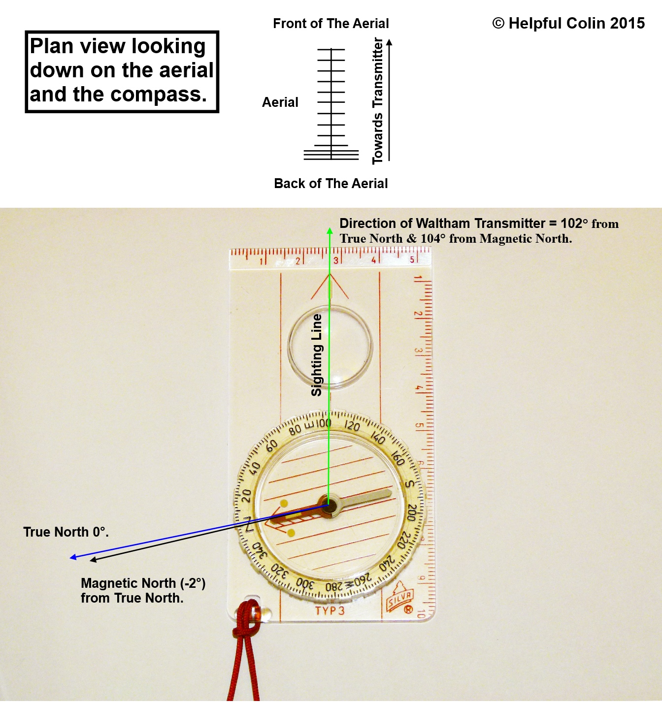
NOTE: In the diagram above the compass needle, pointing to Magnetic North, has been aligned with N (zero) on the dial. Then true north is at 2° on the dial. When my aerial points to the Waltham transmitter the sighting direction is aligned with 104° on the compass dial.
Having set the compass I stood on the ground, about 10m behind the aerial, where I could still see it. I held the compass so that it was pointing directly away from me with the Sighting Line pointing towards the back of the aerial and in line with the direction the aerial was pointing and on towards the transmitter. I adjusted my position by walking left or right on the ground until the sighting line appeared to point in the same direction as the centre bar of the aerial.
Checking An Aerial That Is Correctly Aligned
Fig. A (below) shows how my aerial looks, in relation to a compass, when it is correctly aligned at 104° from magnetic north (slightly south of East).
In Fig. A
With a correctly aligned aerial the compass needle points to N (Magnetic North) on the dial whilst the sighting line runs through the transmitter’s magnetic bearing of 104°, on the compass scale, and aligns with the aerial centre bar.

Checking And Adjusting An Aerial That Is Misaligned
Fig. B and Fig. C (above) show two ways how an aerial could look, in relation to a compass, if it were misaligned.
In Fig. B
The compass is set so that the transmitter magnetic bearing aligns with the sighting line. It’s being held so that it points to the aerial mast and the transmitter. Because the aerial is not pointing to the transmitter its centre bar is not in line with the sighting line as in Fig. A.
In this example the aerial is pointing too far south. So the mast must be turned anti-clockwise, when viewed from above, to get it to point to the transmitter. The front of the aerial will then point nearer to the east. It’s shown pointing too far south.
In Fig. C
The compass is set so that the transmitter magnetic bearing aligns with the sighting line. It’s being held so that the sighting line is aligned with the aerial Centre Bar. However the compass needle is not pointing to N (Magnetic North) on the dial as in Fig. A.
In this example the aerial is pointing too far north. So the mast must be turned clockwise, when viewed from above, to get it to point to the transmitter. The front of the aerial will then point further south.
The person holding the compass must walk on a circular path to the left whilst continuing to point it at the mast. They must stop when the needle points to N (Magnetic North). The mast must be turned until the observer with the compass can see that it is aligned, as in Fig. A.
Then I Found The Easy Way To Check My Terrestrial Freeview TV Aerial Direction
- Get the direction (azimuth preferably magnetic azimuth) using the Terrestrial Calculator by Charles Macfarlane specifically designed for this purpose. Locations west of Greenwich require the latitude to have a minus sign. Angles in this calculator are entered as degrees and minutes (52°53′) or degrees with a decimal value (52.883333). Degrees and minutes are converted to a decimal value by the calculator on entry.
- Set the sighting line of the compass to the magnetic azimuth.
- Walk around the aerial mast keeping the sighting line pointed at it. Look where the compass needle points. When it points to the north (N on the adjustable dial) look at the aerial. Is it pointing in line with the sighting line of the compass? If not adjust it until it does.
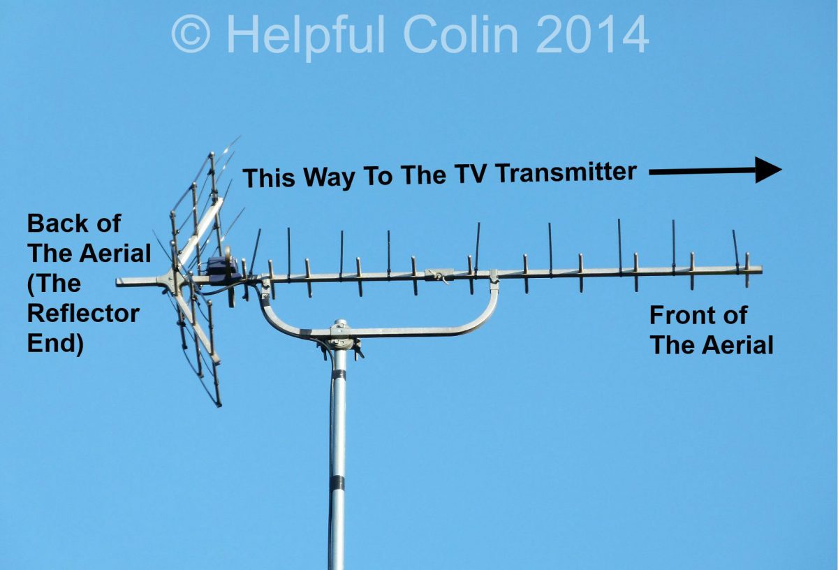
See Which Way A TV Aerial Should Point
If you aren’t sure which way an aerial should point take a look at the featured image repeated below:

NOTE: The extra spiky things on the Yagi antenna/aerial above are zip ties put there to prevent birds landing on it. Please see my post: Keeping Birds off TV Aerials for more information.
Leave a Reply